T1#military#standard#japan
GPS — The Day a Military Navigation System Opened Up Its Accuracy
Metadata
- Date
- Decade
- 2000s
- Tier
- T1
- Sources
- 13
- Connections
- 00
- Tags
- #military#standard#japan
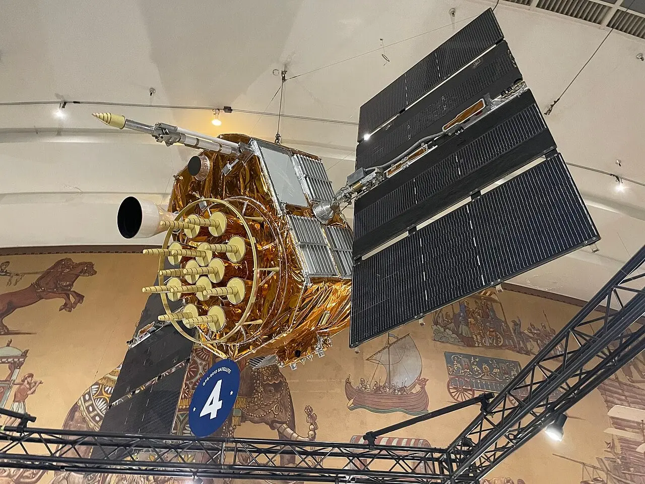
GPS (the Global Positioning System) is a satellite navigation system owned by the United States and operated by the US Space Force. A receiver picks up signals from satellites overhead and calculates its own position and the time. Civilian use began on a limited basis with the first satellites in 1978, but the civil signal carried Selective Availability (SA), which deliberately reduced its accuracy. On 1 May 2000 President Bill Clinton announced that SA would stop at midnight that night, and civilian GPS became able to pinpoint locations up to ten times more accurately.
| Date | Event |
|---|---|
| 1973 | The Joint Program Office (JPO) lays out the GPS architecture and starts a prototype |
| 22 February 1978 | The first Navstar satellite is launched |
| 16 September 1983 | After the Korean airliner is shot down, the US says it will open GPS to civil aircraft |
| 14 February 1989 | The first operational Block II satellite is launched |
| 8 December 1993 | Initial operational capability (IOC) is declared |
| 27 April 1995 | Full operational capability (FOC) is declared |
| 1 May 2000 | President Clinton announces the end of SA (it stopped just after midnight EDT, on 2 May) |
| September 2007 | The US says GPS III will be procured without SA |
| 1 November 2018 | Japan's Michibiki quasi-zenith system begins four-satellite service |
Three segments
According to GPS.gov, GPS has three segments: space, control and user. The space segment is the constellation of satellites broadcasting one-way signals that give their current position and time. The United States commits to keeping at least 24 operational satellites available 95% of the time, and the satellites circle the Earth twice a day in medium Earth orbit at about 20,200 km. They are arranged in six orbital planes of four slots each, which lets users see at least four satellites from virtually anywhere. GPS.gov reported 31 operational satellites as of 3 July 2023.
The control segment is a worldwide network of monitor and control stations that keep the satellites in their orbits and adjust their clocks. The user segment is the receiver, which turns the signals into three-dimensional position and time. The civilian service is freely available to all users, continuously and worldwide.
From the 1973 plan to full operation in 1995
According to an article by the GPS Directorate at Los Angeles Air Force Base, in 1973 the Navstar GPS Joint Program Office, headed by then-Colonel Bradford Parkinson, developed the GPS architecture and set out to field a prototype proving that space-based global navigation would work. The Air Force Historical Foundation records that the first Navstar satellite was launched on 22 February 1978 from Vandenberg Air Force Base in California on an Atlas F booster and became operational on 31 March.
The same Air Force article says that once the first four developmental Block I satellites were up in 1978, GPS began providing three-dimensional positioning, navigation and timing to military and civilian users on a limited but worldwide basis. The remaining seven Block I satellites were launched by 1985. The first operational Block II satellite went up on 14 February 1989, and on 8 December 1993, with 24 Block I and Block II/IIA satellites in orbit, Air Force Space Command declared initial operational capability (IOC). On 27 April 1995 it declared full operational capability (FOC), with 24 operational Block II/IIA satellites in their assigned slots.
1983: after the Korean airliner
The State Department's historical record notes that on 1 September 1983 a Soviet fighter shot down Korean Air Lines Flight 007, which had strayed into Soviet airspace near Sakhalin, killing all 269 people on board. On 16 September Deputy Press Secretary Larry Speakes read a statement saying that, as a contribution to preventing such a tragedy, the President had determined that the United States was prepared to make the facilities of its Global Positioning System available to civilian aircraft when it became operational in 1988, giving airliners three-dimensional position information.
The episode is often retold as Reagan making GPS free for civilian use, and English Wikipedia summarises it that way. The statement itself speaks of civilian aircraft and of 1988; the word "free" does not appear.
What Selective Availability was
GPS.gov describes SA as an intentional degradation of public GPS signals implemented for national security reasons. The White House fact sheet of 2000 explains that with SA in place, car navigation could locate a vehicle only to within about a hundred metres, which made it hard to tell which of several parallel highways a car was on.
In a Presidential Decision Directive of March 1996, Clinton had committed to ending the use of SA by 2006, with an annual assessment of its continued use starting in 2000. According to his statement, the decision to stop was based on a recommendation by the Secretary of Defense, coordinated with the Departments of State, Transportation and Commerce, the Director of Central Intelligence and others. The military had demonstrated the ability to deny GPS signals regionally when national security was threatened, so global degradation was no longer needed.
The announcement of 1 May 2000
In his statement of 1 May 2000 Clinton announced that the United States would stop the intentional degradation of the GPS signals available to the public beginning at midnight that night. Civilian users, he said, would be able to pinpoint locations up to ten times more accurately than before.
| Item | Detail |
|---|---|
| Announcement | Presidential statement, 1 May 2000 |
| Time of the change | A few minutes past midnight EDT after the end of 1 May, across all satellites at once |
| In UTC | All satellites stopped adding the SA error at about 04:05 UTC on 2 May |
| Accuracy | Up to ten times better in the President's statement; 20 metres or better expected in the fact sheet |
| Users | More than 4 million worldwide (2000 fact sheet) |
Times are from the GPS.gov FAQ and its first-week data.
The fact sheet expected the GPS market to double in three years, from $8 billion to over $16 billion. Beyond car navigation, it named Enhanced 911 location for emergency calls from mobile phones, hiking, camping and fishing. According to the GPS.gov FAQ, existing receivers got the higher accuracy without modification, and because SA could not be applied region by region, switching it off improved accuracy for the whole world at once.
The US government says it has no intent to use SA again. According to GPS.gov, in September 2007 it announced that the next generation, GPS III, would be procured without the SA feature, making the 2000 decision permanent.
When location became a given
More accurate GPS moved into devices. The self-driving cars of the 2005 DARPA Grand Challenge carried GPS antennas on their roofs, and the 2008 iPhone 3G built in GPS so the Maps app could follow the user's position as a dot. In 2016 Pokémon GO turned real-world location into the playing field.
Japan's Michibiki
Satellite positioning is not only American. Japan's Cabinet Office describes Michibiki, the Quasi-Zenith Satellite System (QZSS), as Japan's satellite positioning system built mainly around satellites in quasi-zenith orbits that pass almost directly over Japan, and notes that it is sometimes called the Japanese GPS. In cities and mountains, buildings and trees cut down the number of GPS satellites in view, and Michibiki fills that gap.
According to Mitsubishi Electric, the first satellite was launched on an H-IIA rocket on 11 September 2010 (it was retired on 15 September 2023). Units 2 to 4 joined in 2017 to form a four-satellite system, and from 1 November 2018 users could receive uninterrupted, round-the-clock service complementing and augmenting GPS. Unit 6 was launched on 2 February 2025, but unit 5, launched on 22 December 2025, failed to reach orbit when the second-stage engine of the eighth H3 rocket malfunctioned. No launch date has been set for unit 7.
For hardware generally, see the hardware timeline.
Questions this page answers
- When did civilians start using GPS?
- According to the Air Force, limited worldwide service to military and civilian users began in 1978 once the first four Block I satellites were in orbit, and in 1983 the US government said it would open GPS to civilian aircraft. The civil signal was deliberately degraded, however, until just after midnight Eastern Daylight Time at the end of 1 May 2000.
- What was Selective Availability?
- An intentional degradation of the public GPS signal, imposed for national security reasons. It was switched off in May 2000 at President Clinton's direction, and the US government says it has no intent to use it again. In September 2007 it announced that GPS III satellites would be procured without the SA feature.
- How many GPS satellites are there?
- The United States commits to keeping at least 24 operational satellites available 95% of the time. According to GPS.gov there were 31 operational satellites as of 3 July 2023, in medium Earth orbit at about 20,200 km, each circling the Earth twice a day.
- How is Japan's Michibiki related to GPS?
- Michibiki, the Quasi-Zenith Satellite System (QZSS), is Japan's satellite positioning system. Built around satellites whose orbits pass nearly overhead in Japan, it is used together with GPS; the Cabinet Office describes its role as complementing GPS where buildings or mountains block satellites. Four-satellite service began on 1 November 2018.
Sources
SA to stop at midnight; up to ten times more accurate; the March 1996 Presidential Decision Directive and the commitment to end SA by 2006
PrimaryImproving the Civilian Global Positioning System (GPS) — White House fact sheet, May 1, 2000
More than 4 million users worldwide, a market expected to grow from $8 billion to over $16 billion in three years, benefits for car navigation, E911 and outdoor use
PrimarySelective Availability — GPS.gov
Definition of SA, its discontinuation in May 2000, and the September 2007 decision to procure GPS III without SA
PrimaryFrequently Asked Questions About Selective Availability — GPS.gov
Ended a few minutes past midnight EDT after 1 May, simultaneously across the constellation; it could not be applied regionally
PrimaryData From the First Week Without Selective Availability — GPS.gov
All satellites stopped introducing the SA error at about 04:05 UTC on 2 May 2000
PrimarySpace Segment — GPS.gov
Commitment to 24 satellites 95% of the time; 31 operational as of 3 July 2023; about 20,200 km altitude; six orbital planes
The 1973 Joint Program Office under Parkinson, limited service from 1978, the first Block II on 14 February 1989, IOC on 8 December 1993 and FOC on 27 April 1995
SecondaryFebruary 22, 1978 — Air Force Historical Foundation
Atlas F launch of NAVSTAR 1 from Vandenberg; operational on 31 March
Statement that the US was prepared to make GPS available to civilian aircraft when operational in 1988
On 1 September 1983 a Soviet fighter shot down Korean Air Lines Flight 007, killing all 269 aboard
Primary準天頂衛星システム「みちびき」(QZSS) — 三菱電機 宇宙システム
First satellite launched 11 September 2010 (retired 15 September 2023), units 2 to 4 and the replacement, service from 1 November 2018, unit 6 on 2 February 2025, and the failed launch of unit 5 on 22 December 2025
Last updated: